
Landowners who know how their land is valued make better decisions — whether they’re holding, selling, or comparing offers. Landowners who don’t know often find out the hard way that the number they had in mind and the market’s number aren’t the same thing.
The Valuation Methodology: Where It Starts
Land appraisal in Texas follows the same general methodology used across the country but with Texas-specific considerations that change how each element is applied. The primary approach for raw land is the sales comparison approach — identifying comparable sales (comps) and adjusting their prices to account for differences between the comparable properties and the subject parcel.
The income approach is occasionally used for agricultural land where the productive income capacity of the land is a meaningful value driver — rental rates for farmland, grazing rates, or timber income can be capitalized into a value estimate. The cost approach, used primarily for improved properties, has limited application for raw land.
For most North Texas raw land, the sales comparison approach is the primary valuation methodology, which means land comps in Texas are the foundation of any credible value estimate.
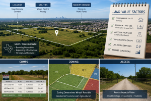
Comps: The Foundation of Land Valuation
A comp — comparable sale — is a recently closed transaction involving a property similar enough to the subject that its price provides useful information about the subject’s likely market value. The challenge with land comps, compared to residential comps, is that truly comparable sales are harder to find. Residential properties in a subdivision can have dozens of nearly identical sales in any given year. Rural or transitional land parcels are all unique in ways that matter — size, location, access, development potential — and finding sales that are genuinely comparable requires both market access and judgment.
What Makes a Good Land Comp
Proximity and recency are the primary qualifiers for a useful comp. In the North Texas growth market, where land values can move significantly in 12 to 24 months, a sale from three years ago may tell you more about where the market was than where it is. Sales within 12 months are strongly preferred; sales older than 24 months require meaningful adjustment if they’re to be used at all.
Beyond recency, a useful comp is similar in development stage (raw land, agricultural land, platted lots, permitted development), in access and utility availability, in zoning or land use classification, and in general market position (infill versus exurban, near growth infrastructure versus remote). A sale of heavily improved agricultural land near Denton does not comp meaningfully against a raw infill site near Frisco even if the price per acre is similar — they’re in different markets with different buyer pools and different value drivers.
The County Appraisal District Is Not Your Comp Source
One of the most common mistakes landowners make when assessing their own land value is using the county appraisal district (CAD) assessed value as a proxy for market value. CAD assessments are the basis for property tax calculation, not a market valuation. They lag the market — often significantly — and they’re derived from mass appraisal methodology rather than individual property-specific analysis. In a rising market like North Texas has experienced, CAD values can be substantially below actual market values. Conversely, in a correction or a market segment that has softened, CAD values may lag above current market values. Neither direction is useful for a landowner trying to understand what their land would actually bring.
“The CAD assessment tells you what the county thinks it’s worth for tax purposes. The market comp tells you what a buyer would actually pay. These are often very different numbers in North Texas.”
Zoning: The Permission Structure That Shapes Value
Zoning — the legal permission structure that governs what can be built or done on a piece of land — is one of the most powerful drivers of land value and one of the most commonly misunderstood by landowners who aren’t actively engaged in the development market.
The core principle is that land is valued by its highest and best use, and zoning defines what the legal highest and best use is or could be. Agricultural land adjacent to a growing suburb doesn’t primarily derive its value from its farming productivity — it derives its value from what it could become when the development frontier reaches it. The buyer pricing that land isn’t thinking about crop yields; they’re thinking about residential lots, industrial buildings, or commercial pads.
Zoned vs. Entitled vs. Raw
There’s an important distinction between land that is currently zoned for a higher use, land that has received specific entitlements or permits for a particular development (entitled), and raw land that might eventually be rezoned but currently has no such permission. Each stage represents a progressively de-risked position for a developer, and the price premium moves accordingly:
Raw agricultural land with no zoning change likely: modest premium over agricultural value based on general development proximity. Land in the path of development with clear rezonable potential: meaningful premium as the market anticipates the transition. Land already zoned for commercial or residential use: significant premium that reflects the removed regulatory risk. Entitled land with approved plans and permits: maximum premium reflecting near-full development risk removal.
North Texas landowners near growth corridors — the DFW exurban ring particularly — often own land that is in the second category: clearly in the development path, not yet zoned for it, with a value that is pricing in the probability of that transition. Understanding where your land sits in this progression is essential for evaluating any offer.
Access: The Value Factor That’s Easy to Overlook
Access is one of the most significant land value factors in North Texas and one of the most commonly underweighted by landowners who assume their land is accessible because they can reach it.
For development purposes, the access that matters is legal, deeded, year-round access via a public road or a recorded private easement. Agricultural roads, permissive use access across a neighbor’s property, and informal arrangements that have worked for generations are not the same as legal access — and buyers (and their lenders and title companies) will not treat them as equivalent.
Highway Frontage: The Premium Access
Direct frontage on a state highway or US highway in North Texas commands a significant premium over otherwise comparable parcels without frontage. Commercial and industrial buyers, in particular, require highway exposure. Even for residential development, highway-adjacent land that provides access to arterial roads for a subdivision has meaningful value that landlocked or county road-only land doesn’t.
The length of highway frontage and the specific highway matter. US-75, US-380, US-287, and similar high-traffic corridors in the DFW growth area carry different commercial value than a rural Farm-to-Market road with lighter traffic. The access value has to be calibrated to the specific road rather than treated as a binary highway/no highway distinction.
Utilities: What’s Available vs. What’s Possible
Utility availability — electricity at the site, water and sewer service available within reasonable extension distance, natural gas in the area — affects land value significantly for development purposes. A parcel with existing utility connectivity is worth more than one that requires significant extension or alternative utility development. The cost to bring utilities to a parcel is a direct deduction from the land’s development value, and buyers price accordingly.
Agricultural land in confirmed growth path + highway frontage + utilities available + zoning rezonable: highest value tier. Agricultural land in probable growth path + paved road access + utilities nearby: mid-value tier. Agricultural land without confirmed development path + limited road access + utility extension required: lower value tier, primarily agricultural/investment market. The differences between these tiers in the DFW exurban market can be 200-500% in price per acre on otherwise similar parcels — proximity, access, and infrastructure do most of the heavy lifting.
For sellers and landowners who want an honest current market assessment for their specific parcel, a conversation with a broker who actively works the North Texas land market is more informative than any formula or county assessment could be. The Airstream Realty contact and consultation page is the right starting point for a specific land value conversation. For buyers exploring what’s available across property types — agricultural land, residential land, commercial property, and off-market opportunities — the full Texas land listing inventory gives the market context. For a specific example of a well-positioned highway-adjacent parcel, this 350-acre Highway 410 frontage tract near San Antonio illustrates how highway access and infrastructure position interact with a Texas growth market to determine value. And for everything about the practice, Airstream Realty is the right resource.
Frequently Asked Questions
How is land valued differently from residential property in North Texas?
Residential property valuation relies heavily on the sales comparison approach using comparable homes — a methodology that works well because there are typically many recent sales of similar properties within a defined area. Land valuation also uses the sales comparison approach but with fewer and more varied comparables, requiring greater appraiser judgment in making adjustments for differences between parcels. Land valuation also relies more heavily on highest and best use analysis — what the land could become, not just what it currently is — which means factors like zoning potential, proximity to development, and infrastructure availability carry more weight in land appraisal than in residential appraisal.
Why is the county appraisal district value unreliable for determining land value?
County appraisal district (CAD) values are determined through mass appraisal methodology — systematic processes applied uniformly across large property groups rather than individual property analysis. They are designed to be administratively efficient and legally defensible for tax purposes, not to precisely reflect current market values. In North Texas’s rapidly appreciating land market, CAD values typically lag actual market values by one to several years. A landowner comparing CAD assessed value to a market offer is comparing a lagging estimate to a current-market number — the gap can be tens or hundreds of thousands of dollars on a meaningful parcel, and the direction of the gap depends entirely on whether the market has moved up or down since the last assessment cycle.
How much does highway frontage add to land value in North Texas?
The premium for direct highway frontage on a state or US highway in North Texas varies considerably by the specific highway and its traffic volume, but it is consistently meaningful — often 20% to 100% or more above otherwise comparable non-frontage land. Commercial and industrial buyers specifically seek highway exposure and pay accordingly. Even for residential development, highway access to an arterial road network has value that county road or private road-only access doesn’t match. The specific premium depends on the highway class, traffic count, surrounding development density, and the highest and best use the frontage enables — a one-size-fits-all premium estimate isn’t credible, but the direction of the impact is consistently positive and often substantial.
What land comps should I look at to assess my North Texas land value?
The most useful land comps are closed sales (not asking prices) of properties that are similar in size, location, development stage, access, and zoning within the past 12 to 24 months. Closed sale data is available through county deed records (public record in Texas), through the MLS for listed transactions, and through specialized land market data services. The challenge for landowners doing their own comp analysis is that truly similar sales may be sparse, the necessary adjustments for differences between properties require market judgment, and asking prices — which are widely available — don’t reflect what buyers actually paid. Working with an active land broker or a licensed appraiser with specific Texas land experience produces a more reliable estimate than self-administered comp analysis in most cases.
Does zoning significantly affect land value in North Texas?
Yes, significantly. Zoning defines the legal highest and best use of a parcel, which is the primary driver of land value in the development market. Agricultural land that can be rezoned for residential development is valued at a meaningful premium over land with no foreseeable rezoning path, because the potential transition reduces risk for development buyers. Land already zoned for commercial or industrial use commands a further premium that reflects the removed regulatory risk. The entitlement stage — approved permits and plans — commands the highest premium before actual improvement. In the DFW exurban growth market, the difference in value between similar land at different zoning/entitlement stages can be several hundred percent per acre.
Should I get an appraisal or work with a broker to value my North Texas land?
Both serve different purposes. A certified appraisal by a licensed appraiser with specific Texas land experience produces a formal written valuation document with the credibility to support financing, legal proceedings, estate matters, or IRS-related transactions. A broker’s opinion of value from an active North Texas land market participant provides a current-market perspective that may be more dynamically calibrated to recent market conditions, and it comes with access to the buyer network and market intelligence that a formal appraisal doesn’t include. For transactional purposes — deciding whether to sell, evaluating an offer, or understanding your position — a broker conversation is often the faster and more actionable starting point. For formal valuation needs, a licensed appraiser is appropriate.