
Zoning is one of those topics that people assume they understand until they’re actually trying to do something with a piece of land — and then discover that the rules are more layered, more jurisdiction-specific, and more consequential than they expected.
How Zoning Authority Works in Texas
Texas is a home-rule state, which means cities have broad authority to regulate land use within their incorporated limits — and a meaningful distance beyond them — under the enabling legislation in the Texas Local Government Code. This authority is exercised through comprehensive plans (which establish the policy direction for land use) and zoning ordinances (which implement that policy through specific, enforceable regulations).
The important wrinkle in the DFW context: not all land in North Texas is zoned. Unincorporated areas — land outside any city’s corporate limits and outside any city’s ETJ — are generally not subject to zoning in Texas. This is different from many other states where counties have zoning authority. Texas counties have very limited land use regulatory authority. Most county-level land use controls in Texas are limited to subdivision regulations and floodplain management rather than the use-restriction zoning that cities exercise.
What this means practically: a tract of land in unincorporated Collin County or Parker County is not subject to use restrictions the way land inside a city limit or ETJ is. Agricultural use, residential development, light commercial, and many other uses can occur on unincorporated land without zoning approval — subject only to state law, deed restrictions, and any applicable county subdivision regulations. This characteristic of rural and semi-rural North Texas land is one of the things that makes it attractive for certain uses and buyers, and one of the things that produces surprise when a buyer from a more regulated state encounters it for the first time.
“Texas doesn’t zone unincorporated land the way most states do. Outside a city and its ETJ, land use is generally governed by what the owner wants to do with it, state law, and deed restrictions — not a county zoning map.”
The ETJ: The Zone Between City and County
The extraterritorial jurisdiction (ETJ) is one of the more important and less understood aspects of land use in Texas. Texas law allows cities to extend their planning and subdivision authority into unincorporated areas surrounding the city — the ETJ — as a buffer zone for future annexation and development management.
ETJ width is determined by the city’s population: cities with populations under 5,000 have a half-mile ETJ; cities of 5,000 to 24,999 have a one-mile ETJ; cities of 25,000 to 49,999 have a two-mile ETJ; cities of 50,000 to 99,999 have a three-and-a-half-mile ETJ; and cities of 100,000 or more have a five-mile ETJ. In the DFW context, with dozens of incorporated cities of varying sizes, these ETJ zones overlap and create a complex patchwork of authority that covers most of the developed and near-developed areas of the metroplex.
Within the ETJ, cities can enforce subdivision regulations — requiring platting, infrastructure standards, and other development-related requirements — but they cannot enforce full zoning use restrictions. A buyer of land in a city’s ETJ is not subject to the city’s zoning ordinance, but is subject to the city’s subdivision ordinance if they’re developing or subdividing. And critically: land in the ETJ can be annexed by the city at any point, bringing it under full city zoning authority. This potential for future annexation affects how buyers should evaluate land in ETJ areas.
Inside City Limits: How DFW Zoning Categories Work
For land inside an incorporated city in the DFW area, zoning in North Texas follows the standard American zoning framework with city-specific variations. The general categories — residential, commercial, industrial, agricultural — each have subcategories that define increasingly specific use and development standards.
Residential Zoning
Residential zoning in DFW cities is typically organized by density and lot size. SF-1, SF-2, SF-3 (or similar designations that vary by city) indicate single-family residential zones with progressively smaller minimum lot sizes or higher density. Multi-family zones (MF, apartments, townhomes) have their own categories. The specific designations and standards differ meaningfully between cities — a “SF-1” in one DFW city may not have the same minimum lot size or setback requirements as “SF-1” in an adjacent city.
Agricultural Zoning
Agricultural (AG) zoning designations in DFW cities are common for large-lot rural transitional areas on the urban fringe. In many DFW cities, AG-designated land allows agricultural use, single-family residential at low density, and limited ancillary uses — but not commercial or industrial development. AG zoning is frequently a “holding zone” for land that’s expected to eventually transition to higher-use designations as development pressure reaches it. Understanding whether AG-zoned land is genuinely agricultural or effectively a pre-development holding classification affects how to evaluate its value and potential.
Commercial and Industrial
Commercial zoning (C-1, C-2, Retail, General Business, etc.) and industrial zoning (Light Industrial, Heavy Industrial, Business Park, etc.) designations define what non-residential uses are permitted. These categories have significant implications for land value — commercially zoned land with highway frontage in a growing DFW corridor trades at a dramatically higher price per acre than comparable land without commercial zoning or frontage.
Rezoning: What It Is and What It Actually Takes
Rezoning — formally changing a parcel’s zoning designation — is the mechanism by which land transitions from one use category to another as development pressure changes what’s highest and best use for a given location. Understanding how rezoning land in Texas actually works separates buyers and sellers who understand their property’s development potential from those who don’t.
The rezoning process in any DFW city involves several stages. An application is submitted to the city’s planning department with documentation of the requested change and the proposed use. The planning staff reviews the application against the city’s comprehensive plan, existing zoning patterns, infrastructure capacity, and applicable planning policies. The case is presented to the Planning and Zoning Commission (P&Z), which makes a recommendation. The case then goes to the City Council, which makes the final decision.
The timeline varies by city and complexity. A straightforward rezoning request consistent with the comprehensive plan might move through the process in 60 to 90 days. A contested rezoning requiring detailed traffic studies, environmental review, or significant community engagement can take six months to a year or longer. And there’s no guarantee — the City Council can deny a rezoning application even with P&Z support.
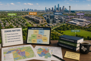
The Comprehensive Plan as the Rezoning Roadmap
The most useful document for evaluating rezoning potential is the city’s comprehensive plan — specifically its future land use map, which indicates what uses the city anticipates and plans for in each area of its jurisdiction. Land that’s currently zoned agricultural but shown as commercial on the future land use map is in a favorable position for commercial rezoning — the city has already indicated its intent for that area, and rezoning applications consistent with the comprehensive plan are significantly more likely to succeed than requests that contradict it.
This is why experienced North Texas land buyers and brokers always review the comprehensive plan before evaluating a parcel’s development potential. The current zoning tells you what you can do now. The comprehensive plan tells you what the jurisdiction intends for the area and how probable a rezoning path is.
Is the land inside a city limit, in the ETJ, or in unincorporated county? The applicable rules differ significantly.
What is the current zoning designation, and what uses does it permit as-of-right?
What is the city’s future land use designation for this area (from the comprehensive plan)?
Is the parcel in any special overlay district (floodplain, historic, TIF, etc.)?
Has there been any ETJ annexation activity in the area that would affect the regulatory picture?
For ETJ land: what are the applicable subdivision regulations, and what’s the annexation risk?
Who is the appropriate planning department contact for questions specific to this parcel?
For buyers exploring land across different categories — agricultural land, residential land, and commercial property — the zoning context for each type is different and worth understanding before evaluating specific listings. The broader Texas land inventory spans multiple zoning contexts, and off-market land opportunities often include parcels where zoning context is part of the value story. For a specific example of a land parcel with its own use and zoning context to consider, the 30-acre Lufkin, TX property listing illustrates how land characteristics and location interact with regulatory context. For questions about a specific parcel’s zoning situation or development potential, the Airstream Realty contact page is the right resource. And for the full picture of the practice, Airstream Realty is the starting point.
Frequently Asked Questions
Is all land in DFW zoned?
No. Land use regulation in the DFW area varies significantly by location. Land inside an incorporated city’s limits is subject to that city’s zoning ordinance. Land in a city’s extraterritorial jurisdiction (ETJ) is subject to the city’s subdivision regulations but not its full zoning code. Land in unincorporated county areas — outside any city and outside any city’s ETJ — is generally not subject to zoning in Texas, as Texas counties have very limited land use regulatory authority compared to counties in most other states. Understanding which regulatory jurisdiction applies to a specific parcel is the first step in understanding what’s permitted on it.
What is the ETJ and how does it affect land use in North Texas?
The extraterritorial jurisdiction (ETJ) is the area surrounding an incorporated city where Texas law allows the city to extend its subdivision regulatory authority in anticipation of future annexation and development. ETJ width ranges from half a mile for small cities to five miles for cities over 100,000 population. In the ETJ, cities can enforce subdivision platting and infrastructure standards but cannot enforce full use-restriction zoning. ETJ land can be annexed by the adjacent city at any time, which would bring it under full city zoning. In the DFW metroplex, with many cities of varying sizes, ETJ boundaries overlap and create a complex regulatory patchwork that varies significantly within short distances.
How long does rezoning take in DFW cities?
Rezoning timelines in DFW cities vary by city, case complexity, and whether the request is consistent with the city’s comprehensive plan. A straightforward rezoning consistent with the future land use map might process through Planning & Zoning Commission and City Council review in 60 to 90 days. Cases requiring traffic impact studies, environmental review, neighborhood notification processes, or significant community engagement can take six months to a year or longer. Rezoning is not guaranteed — City Council has final authority and can deny requests even with P&Z recommendation. Buyers evaluating parcels based on rezoning potential should build realistic timelines and contingency into any development plan.
What is agricultural zoning in DFW, and does it mean the land can only be farmed?
Agricultural (AG) zoning in DFW cities permits agricultural use but typically also allows single-family residential at low density and limited ancillary uses. It does not restrict the land to farming only. In the DFW growth market, AG zoning frequently functions as a holding designation for land in the development path that hasn’t yet been rezoned to its anticipated higher use. The existence of AG zoning doesn’t indicate that the land is permanently limited to agricultural use — reviewing the city’s future land use map and the surrounding development pattern gives a much better picture of what the land’s actual use trajectory is likely to be.
How do I find the zoning of a specific parcel in DFW?
For land inside an incorporated city, the city’s planning department is the authoritative source — most DFW cities have GIS mapping tools on their websites that allow parcel-level zoning lookups. The county appraisal district (CAD) website also typically shows basic land use and zoning information. For ETJ land, the adjacent city’s planning department can confirm ETJ boundaries and applicable subdivision regulations. For unincorporated county land, the county’s flood plain administrator and subdivision coordinator are the relevant contacts, as zoning in the traditional sense doesn’t apply. A Texas real estate attorney or a land broker active in the specific area can help interpret what the applicable regulatory framework means for a specific parcel’s use potential.
What is the difference between a zoning ordinance and a comprehensive plan in Texas?
A comprehensive plan (sometimes called a master plan or general plan) is a policy document that establishes a city’s long-term vision and goals for land use, transportation, parks, infrastructure, and community development. It includes a future land use map showing intended land use patterns across the city. A zoning ordinance is the legally enforceable regulation that implements the comprehensive plan’s policies through specific use and development standards applied to individual parcels. The comprehensive plan guides zoning decisions but doesn’t legally bind them — rezoning applications consistent with the comprehensive plan are significantly more likely to succeed, but cities retain discretion in their zoning decisions. In Texas, cities are required to adopt a comprehensive plan before adopting or amending zoning regulations.